
Bus route 53 in Manchester runs between “Cheetham Hill Shopping Centre” and “Salford Shopping Centre”. In one direction or the other it serves 8 stops that it skips on the way back. The return journey ends at “Arlington Street” (250 m from “Cheetham Hill Shopping Centre”).
The route of bus 53
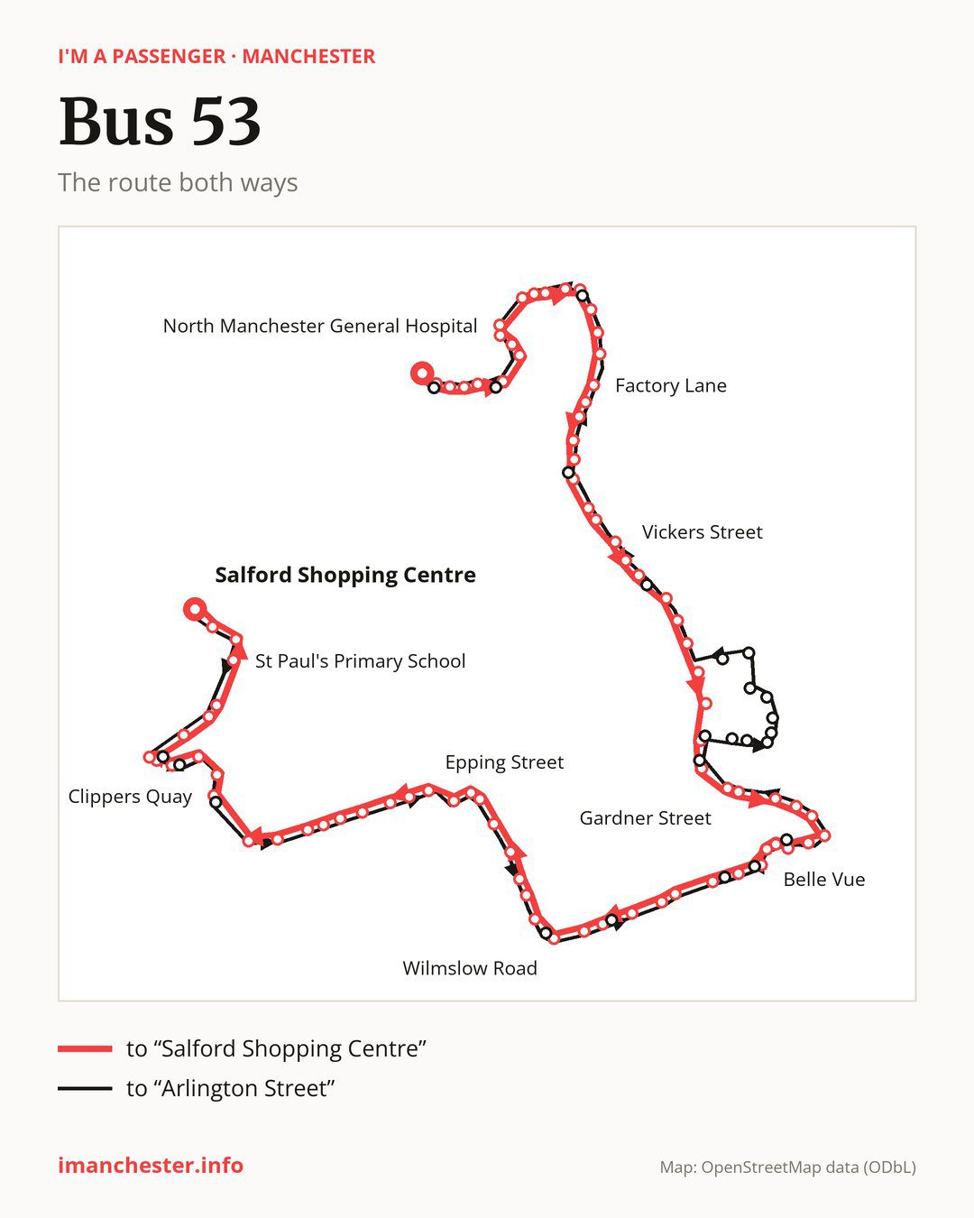
From “Cheetham Hill Shopping Centre” to “Salford Shopping Centre”: 81 stops. On the way: “Cravenwood Road”, “Humphrey Street”, “Abraham Moss Centre”, “Ash Tree Road”, “Saddlecote Close”, “North Manchester General Hospital”, “Crumpsall Vale”, “Chapel Lane”, “Pike Fold Primary School”, “Lion Street”. Then “Sandy Brow”, “Charlestown Road”, “Old Road”, “Parkmount Road”, “Factory Lane”, “Oak Bank”, “Ash Street”, “Kingsbridge Road”, “Lathbury Road”, “Manchester Communication Academy”. Then “Monsall Street”, “Sedgeford Road”, “Oldham Road”, “Vickers Street”, “Lord North Street”, “Briscoe Lane”, “Coop Live”, “Etihad Campus”, “Velopark Metrolink Stop”, “Sunny Lowry Road”. Then “Ashton Old Road”, “Gorton Road”, “Gardner Street”, “Gorton Monastery”, “Preston Street”, “Peacock Close”, “Borwell Street”, “Gorton Post Office”, “Gorton Shopping Centre”, “Sunny Brow Road”. Then “Belle Vue”, “Fernhill Drive”, “Penketh Avenue”, “Pink Bank Lane”, “Asda”, “Longsight Market”, “Clarence Road”, “Birchfields Road”, “Birch Polygon”, “Wilmslow Road”. Then “Grandale Street”, “Dagenham Road”, “St Mary’s”, “Manchester Royal Infirmary”, “University of Manchester”, “University Shopping Centre”, “Royal Northern College of Music”, “Cambridge Street”, “Epping Street”, “Royce Road”. Then “Hulme Park”, “Mallow Street”, “Erskine Street”, “Cornbrook Street”, “Henrietta Street”, “Henry Street”, “Trafford Bar”, “Clippers Quay”, “Merchants Quay”, “Ontario Basin”. Before “Salford Shopping Centre”: “Central Bay”, “The Lowry”, “MediaCityUK”, “Harbour City Metrolink Stop”, “Oasis Academy”, “Goodiers Drive”, “St Paul’s Primary School”, “Cross Lane”, “Paddington Close”.
On the way back the bus takes a different route, from “Salford Shopping Centre” to “Arlington Street” (87 stops). Only in this direction does it call at “Huron Basin”, “Winnipeg Quay”, “Exchange Quay”, “Dickenson Road”, “Anson Road”, “Elsham Gardens”, “Bourton Drive”, “Hampden Crescent”, “Ashburys Station”, “Alan Turing Way”, “Clayton Lane South”, “Wood Street”, “Greenside Street”, “Parkhouse Street”, “Meech Street”, “Bob Massey Close”, “North Road”, “City Football Academy”, “Bradford Road”, “Park View”, “Old Market Street” and “Charminster Drive”. Only in the direction of “Salford Shopping Centre” does it call at, among others, “Cravenwood Road”, “Sandy Brow”, “Charlestown Road”, “Manchester Communication Academy”, “Lord North Street” and “Briscoe Lane”. For the way back, board nearby: “Cravenwood Road” → “Arlington Street” (50 m), “Sandy Brow” → “Old Market Street” (100 m), “Charlestown Road” → “Old Market Street” (200 m) and “Manchester Communication Academy” → “Park View” (100 m). Towards “Salford Shopping Centre”, board nearby: “Huron Basin” → “The Lowry” (100 m), “Winnipeg Quay” → “Central Bay” (100 m), “Exchange Quay” → “Clippers Quay” (100 m) and “Dickenson Road” → “Wilmslow Road” (100 m).
In practice: you can get to “Parkhouse Street” on this bus only in the direction of “Arlington Street”.
Left column runs down, right column runs up. Filled stops are served both ways, dashed ones only one way: 17 towards “Salford Shopping Centre” and 23 the other way. Tap a stop to see its name.
Where to change
Shared sections with other routes: between “Charlestown Road” and “Lathbury Road” it shares the road with routes 17 and 18; between “Clippers Quay” and “Oasis Academy” it shares the road with route 79; between “Gardner Street” and “Gorton Shopping Centre” it shares the road with route 205.
Connections by stop, in route order:
- “Cheetham Hill Shopping Centre”: buses 52, 59, 94, 135 and 151
- “Cravenwood Road” (only towards “Salford Shopping Centre”): buses 52, 59, 94, 135 and 151
- “Humphrey Street”: buses 52, 59, 94, 135 and 151
- Stops from “Abraham Moss Centre” to “Saddlecote Close”: buses 52, 94 and 151
- “North Manchester General Hospital”: buses 52, 94, 118, 151 and 156
- Stops from “Crumpsall Vale” to “Lion Street”: buses 94, 118 and 156
- “Sandy Brow” (only towards “Salford Shopping Centre”): buses 118 and 156
- “Charlestown Road” (only towards “Salford Shopping Centre”): bus 118
- “Old Road”: bus 118
- “Parkmount Road”: bus 52
- “Factory Lane”: buses 52, 81, 112, 117, 118, 119 and 151
- Stops from “Oak Bank” to “Kingsbridge Road”: buses 52, 81, 112, 117, 118 and 119
- “Lathbury Road”: buses 52, 81, 112, 117, 118, 119, 151 and 156
- “Manchester Communication Academy” (only towards “Salford Shopping Centre”): buses 81, 112, 114, 117, 118, 119, 151 and 156
- “Monsall Street”: buses 81, 112, 114, 117, 118, 119, 151 and 156
- “Sedgeford Road”: buses 83, 84, 114, 151 and 182
- “Oldham Road”: buses 83, 84, 114, 151 and 182
- “Vickers Street”: buses 83, 84, 114 and 182
- “Lord North Street” (only towards “Salford Shopping Centre”): buses 76, 76A and 76B
- “Briscoe Lane” (only towards “Salford Shopping Centre”): buses 76, 76A and 76B
- “Coop Live”: buses 76, 76A and 76B
- “Etihad Campus”: bus 231
- “Velopark Metrolink Stop”: bus 231
- “Borwell Street”: buses 7, 150, 171 and 172
- “Gorton Post Office”: buses 7, 150, 171, 172 and 203
- “Gorton Shopping Centre”: buses 7, 150, 171, 172 and 203
- “Sunny Brow Road” (only towards “Salford Shopping Centre”): buses 7, 150, 171, 172 and 203
- “Belle Vue”: buses 7, 150, 171, 172 and 203
- “Fernhill Drive” (only towards “Salford Shopping Centre”): buses 150 and 203
- “Pink Bank Lane”: bus 150
- “Asda”: buses 150, 191, 192 and 197
- “Longsight Market”: buses 150, 191, 192 and 197
- “Clarence Road”: buses 43, 50, 142, 143 and 147
- “Birchfields Road” (only towards “Salford Shopping Centre”): buses 43, 50, 142, 143 and 147
- “Birch Polygon”: buses 43, 50, 142, 143 and 147
- “Wilmslow Road”: buses 42A, 42B, 43, 142, 143 and 147
- “Grandale Street”: buses 42A, 42B, 43, 142, 143 and 147
- “Dagenham Road”: buses 42A, 42B, 43, 111, 142, 143 and 147
- “St Mary’s”: buses 42A, 42B, 43, 87, 111, 142, 143 and 147
- “Manchester Royal Infirmary”: buses 42A, 42B, 43, 50, 87, 111, 142, 143, 147, 191 and 197
- “University of Manchester”: buses 42A, 42B, 43, 50, 87, 103, 111, 142, 143, 147, 191 and 197
- “University Shopping Centre”: buses 42A, 42B, 43, 50, 85, 85A, 86, 87, 103, 111, 142, 143, 147, 191 and 197
- “Royal Northern College of Music”: buses 42A, 42B, 43, 50, 85, 85A, 86, 87, 103, 111, 142, 143, 147, 191 and 197
- “Cambridge Street”: buses 42A, 42B, 43, 85, 85A, 86, 87, 103, 111, 142, 143, 147, 191 and 197
- “Epping Street”: buses 85, 85A, 86, 103 and 256
- “Royce Road”: buses 86 and 256
- “Hulme Park”: buses 86 and 256
- Stops from “Mallow Street” to “Trafford Bar”: bus 256
- “Ontario Basin”: buses 29 and 50
- “Central Bay” (only towards “Salford Shopping Centre”): buses 29 and 50
- “The Lowry” (only towards “Salford Shopping Centre”): buses 29 and 50
- Stops from “MediaCityUK” to “Oasis Academy”: buses 29 and 50
- “Goodiers Drive” (only towards “Salford Shopping Centre”): bus 33
- “Cross Lane”: bus 50
- “Paddington Close”: buses 50, 52, 70 and 95
- “Salford Shopping Centre”: buses 50, 52, 70 and 95
- “Huron Basin” (only towards “Arlington Street”): buses 29 and 50
- “Winnipeg Quay” (only towards “Arlington Street”): buses 29 and 50
- “Dickenson Road” (only towards “Arlington Street”): buses 42A, 42B, 43, 142, 143 and 147
- “Anson Road” (only towards “Arlington Street”): buses 43, 50, 142, 143 and 147
- “Elsham Gardens” (only towards “Arlington Street”): bus 150
- “Bourton Drive” (only towards “Arlington Street”): buses 150 and 203
- “Hampden Crescent” (only towards “Arlington Street”): buses 7, 150, 171, 172 and 203
- Stops from “Wood Street” to “Bob Massey Close” (only towards “Arlington Street”): buses 171 and 172
- “North Road” (only towards “Arlington Street”): buses 171, 172 and 231
- “City Football Academy” (only towards “Arlington Street”): bus 231
- “Bradford Road” (only towards “Arlington Street”): buses 76, 76A and 76B
- “Park View” (only towards “Arlington Street”): buses 81, 112, 117, 118, 119, 151 and 156
- “Old Market Street” (only towards “Arlington Street”): buses 118 and 156
- “Charminster Drive” (only towards “Arlington Street”): buses 52, 94 and 151
- “Arlington Street”: buses 52, 59, 94, 135 and 151
Pages for these routes: bus 7, bus 17, bus 18, bus 29, bus 33, bus 42A, bus 42B, bus 43, bus 50, bus 52, bus 59, bus 70, bus 76, bus 76A, bus 76B, bus 79, bus 81, bus 83, bus 84, bus 85, bus 85A, bus 86, bus 87, bus 94, bus 95, bus 103, bus 111, bus 112, bus 114, bus 117, bus 118, bus 119, bus 135, bus 142, bus 143, bus 147, bus 150, bus 151, bus 156, bus 171, bus 172, bus 182, bus 191, bus 192, bus 197, bus 203, bus 205, bus 231, bus 256.
Passes and concessions
Which passes are available and who travels free is explained on a separate page: how to pay for public transport in Manchester.
Questions and answers
Does bus 53 stop at “Parkhouse Street”?
Only in the direction of “Arlington Street”: in the other direction it does not stop there.
Does bus 53 go to “North Manchester General Hospital”?
Yes, in both directions.
Where can I change from bus 53 to another bus route?
Most routes stop at “University Shopping Centre” and “Royal Northern College of Music” (42A, 42B, 43, 50, 85, 85A, 86, 87, 103, 111, 142, 143, 147, 191 and 197). All other stops with connections are listed above.
Checked on 28 September 2026. Source of the route and stops: Transport for Greater Manchester (TfGM).