
Bus route 135 in Manchester runs between “Piccadilly Gardens” and “Bury Interchange”.
The route of bus 135
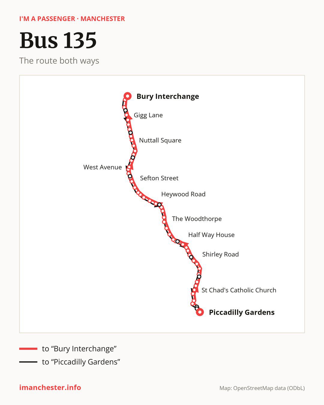
From “Piccadilly Gardens” to “Bury Interchange”: 49 stops. On the way: “The Unicorn”, “Printworks”, “Victoria Rail Station”, “Park Place”, “St Chad’s Catholic Church”, “Derby Street”, “Elizabeth Street”, “Balmfield Street”, “Bignor Street”, “Shirley Road”. Then “Albyns Avenue”, “Copthall Lane”, “Cheetham Hill Shopping Centre”, “George Street North”, “Half Way House”, “Bristol Court”, “Singleton Road”, “Ravensway”, “King’s Road”, “The Woodthorpe”. Then “St Monica’s High School”, “Heaton Park Metrolink Stop”, “Kenyon Lane”, “Orange Hill Road”, “Heywood Road”, “Polefield Hall Road”, “Walker Avenue”, “Besses o’th’ Barn Metrolink Stop”, “Mayfair Avenue”, “Sefton Street”. Then “Pinfold Lane”, “Hamilton Road”, “Morrisons”, “Cross Street”, “West Avenue”, “Selby Avenue”, “Middleton Drive”, “High Bank Road”, “Blackford Bridge”, “Nuttall Square”. Before “Bury Interchange”: “Mount Zion Road”, “Tennyson Avenue”, “Swan & Cemetery”, “Redvales Road”, “Gigg Lane”, “Parliament Street”, “Bury Town Hall”.
The return journey is different. Towards “Piccadilly Gardens”: 52 stops. Only in this direction does it call at, among others, “Holy Cross College”, “Dumers Lane”, “Leslie Avenue”, “Whitefield Metrolink Stop”, “St Margaret’s Cross” and “Park Road”. Only in the direction of “Bury Interchange” does it call at, among others, “The Unicorn”, “Cheetham Hill Shopping Centre”, “Bristol Court”, “Ravensway”, “St Monica’s High School” and “Kenyon Lane”. For the way back, board nearby: “The Unicorn” → “Birchin Lane” (50 m), “Cheetham Hill Shopping Centre” → “George Street North” (200 m), “Bristol Court” → “Park Road” (100 m) and “Ravensway” → “Singleton Road” (150 m). Towards “Bury Interchange”, board nearby: “Holy Cross College” → “Parliament Street” (200 m), “Dumers Lane” → “Tennyson Avenue” (200 m), “Leslie Avenue” → “Middleton Drive” (150 m) and “Whitefield Metrolink Stop” → “Hamilton Road” (100 m).
Left column runs down, right column runs up. Filled stops are served both ways, dashed ones only one way: 7 towards “Bury Interchange” and 10 the other way. Tap a stop to see its name.
Connections
Shared sections with other routes: between “Piccadilly Gardens” and “Albyns Avenue” it shares the road with route 41; between “Cheetham Hill Shopping Centre” and “The Woodthorpe” it shares the road with route 94; between “High Bank Road” and “Redvales Road” it shares the road with route 95.
Connections by stop, in route order:
- “Piccadilly Gardens”: buses 18, 33, 42, 42A, 42B, 43, 59, 76, 76A, 76B, 81, 83, 84, 85, 85A, 86, 87, 103, 111, 112, 114, 117, 118, 119, 142, 143, 182, 192, 203, 205, 231 and 256
- “The Unicorn” (only towards “Bury Interchange”): buses 17, 18, 33, 42, 42A, 42B, 43, 59, 76, 76A, 76B, 81, 83, 84, 85, 85A, 86, 87, 93, 99, 103, 111, 112, 114, 117, 118, 119, 142, 143, 156, 182, 192, 203, 205, 231 and 256
- “Printworks”: buses 17, 18, 33, 59, 81, 93, 99, 112, 114, 117, 118, 119 and 156
- “Victoria Rail Station”: buses 17, 18, 33, 59, 81, 93, 99, 112, 114, 117, 118, 119 and 156
- “Shirley Road”: bus 59
- “Albyns Avenue”: bus 59
- “Copthall Lane”: buses 52, 53 and 59
- “Cheetham Hill Shopping Centre” (only towards “Bury Interchange”): buses 52, 53 and 59
- “George Street North”: buses 52, 53 and 59
- “Half Way House”: buses 52 and 59
- “Bristol Court” (only towards “Bury Interchange”): buses 52 and 59
- “The Woodthorpe”: bus 66
- “St Monica’s High School” (only towards “Bury Interchange”): bus 66
- “Heaton Park Metrolink Stop”: bus 66
- “Kenyon Lane” (only towards “Bury Interchange”): bus 66
- “Woodlands Street” (only towards “Piccadilly Gardens”): buses 52, 53 and 59
- “Turner Street” (only towards “Piccadilly Gardens”): buses 17, 18, 33, 59, 76, 76A, 76B, 81, 83, 84, 93, 99, 112, 114, 117, 118, 119, 156, 182 and 231
- “Birchin Lane” (only towards “Piccadilly Gardens”): buses 17, 18, 33, 42, 42A, 42B, 43, 59, 76, 76A, 76B, 81, 83, 84, 85, 85A, 86, 87, 93, 99, 103, 111, 112, 114, 117, 118, 119, 142, 143, 156, 182, 192, 203, 205, 231 and 256
Pages for these routes: bus 17, bus 18, bus 33, bus 41, bus 42, bus 42A, bus 42B, bus 43, bus 52, bus 53, bus 59, bus 66, bus 76, bus 76A, bus 76B, bus 81, bus 83, bus 84, bus 85, bus 85A, bus 86, bus 87, bus 93, bus 94, bus 95, bus 99, bus 103, bus 111, bus 112, bus 114, bus 117, bus 118, bus 119, bus 142, bus 143, bus 156, bus 182, bus 192, bus 203, bus 205, bus 231, bus 256.
Passes and concessions
Which passes are available and who travels free is explained on a separate page: how to pay for public transport in Manchester.
Questions and answers
Does bus 135 go to “Victoria Rail Station”?
Yes, in both directions.
Where can I change from bus 135 to another bus route?
Most routes stop at “The Unicorn” (only towards “Bury Interchange”; 17, 18, 33, 42, 42A, 42B, 43, 59, 76, 76A, 76B, 81, 83, 84, 85, 85A, 86, 87, 93, 99, 103, 111, 112, 114, 117, 118, 119, 142, 143, 156, 182, 192, 203, 205, 231 and 256) and “Birchin Lane” (only towards “Piccadilly Gardens”; 17, 18, 33, 42, 42A, 42B, 43, 59, 76, 76A, 76B, 81, 83, 84, 85, 85A, 86, 87, 93, 99, 103, 111, 112, 114, 117, 118, 119, 142, 143, 156, 182, 192, 203, 205, 231 and 256). All other stops with connections are listed above.
Checked on 5 October 2026. Source of the route and stops: Transport for Greater Manchester (TfGM).