8 October 2026

Bus route 97 in Manchester: Shudehill Interchange ↔ Bury Interchange

Related

Bus route 183 in Manchester: Laburnum Road ↔ Royal Oldham Hospital

Bus route 183 in Manchester links “Laburnum Road” and...

Bus route 99 in Manchester: Shudehill Interchange ↔ Stanhope Avenue

Bus route 99 in Manchester links “Shudehill Interchange” and...

Bus route 97 in Manchester: Shudehill Interchange ↔ Bury Interchange

Bus route 97 in Manchester links “Shudehill Interchange” and...

Bus route 415 in Manchester: Oldham Bus Station ↔ Middleton Bus Station

Bus route 415 in Manchester links “Oldham Bus Station”...

Bus route 117 in Manchester: Piccadilly Gardens ↔ Moston Road

Bus route 117 in Manchester goes from “Piccadilly Gardens”...

Share

Bus route 97 in Manchester links “Shudehill Interchange” and “Bury Interchange”.

All routes in Manchester →

The route of bus 97

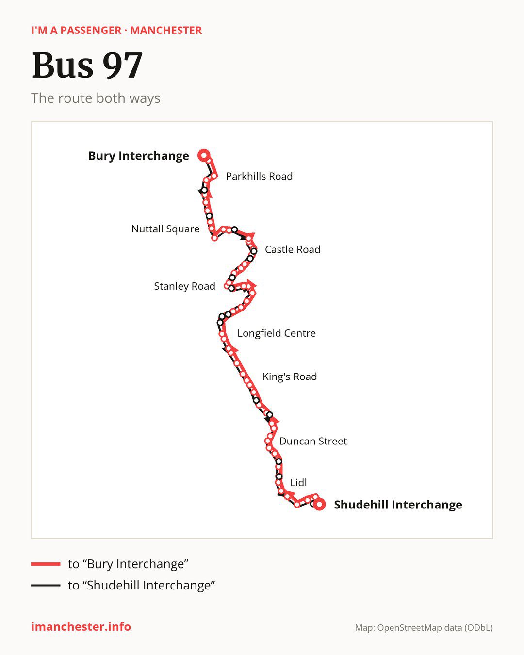
Bus route 97 in Manchester on the map: the route both ways

From “Shudehill Interchange” to “Bury Interchange”: 57 stops. On the way: “Victoria Rail Station”, “Chapel Street”, “Trinity Church”, “Greengate West”, “Silk Street”, “Lidl”, “Lower Broughton Health Centre”, “Broughton Lane”, “Camp Street”, “Great Cheetham Street West”. Then “Murray Street”, “Duncan Street”, “Knoll Street”, “Northumberland Street”, “Broom Lane”, “Park Street”, “Moor Lane”, “King’s Road”, “Crescent Avenue”, “Woodhill Drive”. Then “Butterstile Lane”, “St Mary’s Park”, “Red Lion”, “Longfield Centre”, “Stanhope Avenue”, “Willow Road”, “Conway Avenue”, “Besses o’th’ Barn Metrolink Stop”, “Prestfield Road”, “Stanway Road”. Then “Derwent Avenue”, “Kenmore Way”, “Hindburn Close”, “Oak Lane”, “Lune Drive”, “Stanley Road”, “Laburnum Drive”, “Randale Drive”, “Montgomery Drive”, “Kennedy Drive”. Then “Unsworth Medical Centre”, “Castle Road”, “Church Meadow”, “Sykes Avenue”, “Melton Drive”, “Croft Lane”, “Blackford Bridge”, “Nuttall Square”, “Mount Zion Road”, “Tennyson Avenue”. Before “Bury Interchange”: “Swan & Cemetery”, “Redvales Road”, “Brierley Street”, “Parkhills Road”, “Trinity Street”.

On the way back the bus takes a different route, from “Bury Interchange” to “Shudehill Interchange” (59 stops). Only in this direction does it call at “Gigg Lane”, “Dumers Lane”, “Hollins Community Centre”, “Unsworth Academy”, “Sunny Bank Road”, “Wavell Drive”, “Albert Road”, “Balmoral Avenue”, “Mayfair Avenue”, “Clyde Avenue”, “Mayfield Road”, “Park Lane”, “Muriel Street”, “Health Centre” and “Printworks”. Only in the direction of “Bury Interchange” does it call at, among others, “Chapel Street”, “Lower Broughton Health Centre”, “Camp Street”, “Knoll Street”, “Park Street” and “Willow Road”. For the way back, board nearby: “Chapel Street” → “Printworks” (250 m), “Lower Broughton Health Centre” → “Health Centre” (50 m), “Camp Street” → “Muriel Street” (50 m) and “Knoll Street” → “Duncan Street” (200 m). Towards “Bury Interchange”, board nearby: “Gigg Lane” → “Redvales Road” (150 m), “Dumers Lane” → “Tennyson Avenue” (200 m), “Hollins Community Centre” → “Melton Drive” (200 m) and “Unsworth Academy” → “Castle Road” (50 m).

↓ to “Bury Interchange”↑ to “Shudehill Interchange” Shudehill InterchangeShudehill InterchangeVictoria Rail StationVictoria Rail StationChapel StreetChapel StreetTrinity ChurchTrinity ChurchGreengate WestGreengate WestSilk StreetSilk StreetLidlLidlLower Broughton Health CentreLower Broughton Health CentreBroughton LaneBroughton LaneCamp StreetCamp StreetGreat Cheetham Street WestGreat Cheetham Street WestMurray StreetMurray StreetDuncan StreetDuncan StreetKnoll StreetKnoll StreetNorthumberland StreetNorthumberland StreetBroom LaneBroom LanePark StreetPark StreetMoor LaneMoor LaneKing's RoadKing's RoadCrescent AvenueCrescent AvenueWoodhill DriveWoodhill DriveButterstile LaneButterstile LaneSt Mary's ParkSt Mary's ParkRed LionRed LionLongfield CentreLongfield CentreStanhope AvenueStanhope AvenueWillow RoadWillow RoadConway AvenueConway AvenueBesses o'th' Barn Metrolink StopBesses o'th' Barn Metrolink StopPrestfield RoadPrestfield RoadStanway RoadStanway RoadDerwent AvenueDerwent AvenueKenmore WayKenmore WayHindburn CloseHindburn CloseOak LaneOak LaneLune DriveLune DriveStanley RoadStanley RoadLaburnum DriveLaburnum DriveRandale DriveRandale DriveMontgomery DriveMontgomery DriveKennedy DriveKennedy DriveUnsworth Medical CentreUnsworth Medical CentreCastle RoadCastle RoadChurch MeadowChurch MeadowSykes AvenueSykes AvenueMelton DriveMelton DriveCroft LaneCroft LaneBlackford BridgeBlackford BridgeNuttall SquareNuttall SquareMount Zion RoadMount Zion RoadTennyson AvenueTennyson AvenueSwan & CemeterySwan & CemeteryRedvales RoadRedvales RoadBrierley StreetBrierley StreetParkhills RoadParkhills RoadTrinity StreetTrinity StreetBury InterchangeBury InterchangeBury InterchangeBury InterchangeTrinity StreetTrinity StreetParkhills RoadParkhills RoadBrierley StreetBrierley StreetGigg LaneGigg LaneRedvales RoadRedvales RoadTennyson AvenueTennyson AvenueDumers LaneDumers LaneMount Zion RoadMount Zion RoadNuttall SquareNuttall SquareBlackford BridgeBlackford BridgeCroft LaneCroft LaneHollins Community CentreHollins Community CentreSykes AvenueSykes AvenueChurch MeadowChurch MeadowUnsworth AcademyUnsworth AcademyUnsworth Medical CentreUnsworth Medical CentreSunny Bank RoadSunny Bank RoadKennedy DriveKennedy DriveMontgomery DriveMontgomery DriveWavell DriveWavell DriveStanley RoadStanley RoadAlbert RoadAlbert RoadLune DriveLune DriveHindburn CloseHindburn CloseKenmore WayKenmore WayDerwent AvenueDerwent AvenueStanway RoadStanway RoadPrestfield RoadPrestfield RoadBalmoral AvenueBalmoral AvenueBesses o'th' Barn Metrolink StopBesses o'th' Barn Metrolink StopMayfair AvenueMayfair AvenueClyde AvenueClyde AvenueStanhope AvenueStanhope AvenueLongfield CentreLongfield CentreRed LionRed LionSt Mary's ParkSt Mary's ParkButterstile LaneButterstile LaneWoodhill DriveWoodhill DriveCrescent AvenueCrescent AvenueKing's RoadKing's RoadMayfield RoadMayfield RoadMoor LaneMoor LanePark LanePark LaneBroom LaneBroom LaneNorthumberland StreetNorthumberland StreetDuncan StreetDuncan StreetMurray StreetMurray StreetGreat Cheetham Street WestGreat Cheetham Street WestMuriel StreetMuriel StreetBroughton LaneBroughton LaneHealth CentreHealth CentreLidlLidlSilk StreetSilk StreetGreengate WestGreengate WestTrinity ChurchTrinity ChurchVictoria Rail StationVictoria Rail StationPrintworksPrintworksShudehill InterchangeShudehill Interchange

Left column runs down, right column runs up. Filled stops are served both ways, dashed ones only one way: 13 towards “Bury Interchange” and 15 the other way. Tap a stop to see its name.

Where to change

Shared sections with other routes: between “Shudehill Interchange” and “Stanhope Avenue” it shares the road with route 99; between “Blackford Bridge” and “Bury Interchange” it shares the road with route 95; between “Shudehill Interchange” and “Silk Street” it shares the road with route 93.

Connections by stop, in route order:

  • “Shudehill Interchange”: buses 17, 18, 33, 41, 59, 81, 112, 114, 117, 118, 119 and 156
  • “Victoria Rail Station”: buses 17, 18, 33, 41, 59, 81, 112, 114, 117, 118, 119 and 156
  • “Chapel Street” (only towards “Bury Interchange”): buses 41 and 59
  • “Camp Street” (only towards “Bury Interchange”): bus 52
  • “Great Cheetham Street West”: bus 52
  • “Murray Street”: bus 52
  • Stops from “Crescent Avenue” to “Longfield Centre”: bus 66
  • “Printworks” (only towards “Shudehill Interchange”): buses 17, 18, 33, 41, 59, 81, 112, 114, 117, 118, 119 and 156

Pages for these routes: bus 17, bus 18, bus 33, bus 41, bus 52, bus 59, bus 66, bus 81, bus 93, bus 95, bus 99, bus 112, bus 114, bus 117, bus 118, bus 119, bus 156.

Passes and concessions

Which passes are available and who travels free is explained on a separate page: how to pay for public transport in Manchester.

Questions and answers

Does bus 97 go to “Victoria Rail Station”?

Yes, in both directions.

Where can I change from bus 97 to another bus route?

Most routes stop at “Shudehill Interchange” and “Victoria Rail Station” (17, 18, 33, 41, 59, 81, 112, 114, 117, 118, 119 and 156). All other stops with connections are listed above.

Checked on 7 October 2026. Source of the route and stops: Transport for Greater Manchester (TfGM).

...