

Bus route 99 in Manchester links “Shudehill Interchange” and “Stanhope Avenue”.
Which way bus 99 runs
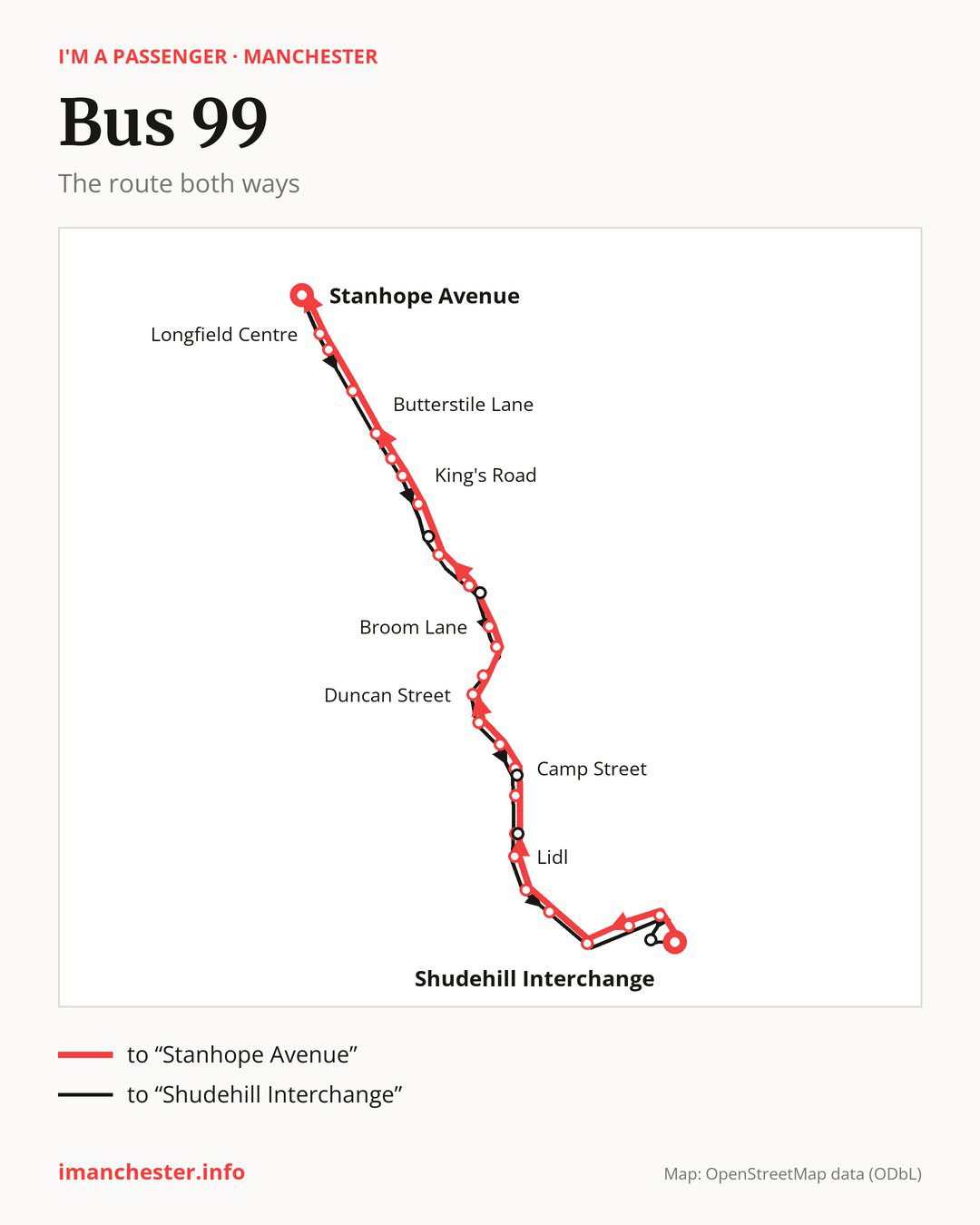
From “Shudehill Interchange” to “Stanhope Avenue”: 26 stops. On the way: “Victoria Rail Station”, “Chapel Street”, “Trinity Church”, “Greengate West”, “Silk Street”, “Lidl”, “Lower Broughton Health Centre”, “Broughton Lane”, “Camp Street”, “Great Cheetham Street West”. Then “Murray Street”, “Duncan Street”, “Knoll Street”, “Northumberland Street”, “Broom Lane”, “Park Street”, “Moor Lane”, “King’s Road”, “Crescent Avenue”, “Woodhill Drive”. Before “Stanhope Avenue”: “Butterstile Lane”, “St Mary’s Park”, “Red Lion”, “Longfield Centre”.
The return journey is different. Towards “Shudehill Interchange”: 26 stops. Only in this direction does it call at “Mayfield Road”, “Park Lane”, “Muriel Street”, “Health Centre” and “Printworks”. Only in the direction of “Stanhope Avenue” does it call at “Chapel Street”, “Lower Broughton Health Centre”, “Camp Street”, “Knoll Street” and “Park Street”. For the way back, board nearby: “Chapel Street” → “Printworks” (250 m), “Lower Broughton Health Centre” → “Health Centre” (50 m), “Camp Street” → “Muriel Street” (50 m) and “Knoll Street” → “Duncan Street” (200 m). Towards “Stanhope Avenue”, board nearby: “Mayfield Road” → “Moor Lane” (200 m), “Park Lane” → “Park Street” (100 m), “Muriel Street” → “Camp Street” (50 m) and “Health Centre” → “Lower Broughton Health Centre” (50 m).
Left column runs down, right column runs up. Filled stops are served both ways, dashed ones only one way: 5 towards “Stanhope Avenue” and 5 the other way. Tap a stop to see its name.
Connections
Shared sections with other routes: between “Shudehill Interchange” and “Stanhope Avenue” it shares the road with route 97; between “Shudehill Interchange” and “Silk Street” it shares the road with route 93; between “Butterstile Lane” and “Longfield Centre” it shares the road with route 94.
Connections by stop, in route order:
- “Shudehill Interchange”: buses 17, 18, 33, 41, 59, 81, 112, 114, 117, 118, 119, 135 and 156
- “Victoria Rail Station”: buses 17, 18, 33, 41, 59, 81, 112, 114, 117, 118, 119, 135 and 156
- “Chapel Street” (only towards “Stanhope Avenue”): buses 41, 59 and 135
- “Camp Street” (only towards “Stanhope Avenue”): bus 52
- “Great Cheetham Street West”: bus 52
- “Murray Street”: bus 52
- Stops from “Crescent Avenue” to “Longfield Centre”: bus 66
- “Printworks” (only towards “Shudehill Interchange”): buses 17, 18, 33, 41, 59, 81, 112, 114, 117, 118, 119, 135 and 156
Pages for these routes: bus 17, bus 18, bus 33, bus 41, bus 52, bus 59, bus 66, bus 81, bus 93, bus 94, bus 97, bus 112, bus 114, bus 117, bus 118, bus 119, bus 135, bus 156.
Passes and concessions
Tickets, passes and concessions are covered on a separate page: how to pay for public transport in Manchester.
Questions and answers
Does bus 99 go to “Victoria Rail Station”?
Yes, in both directions.
Where can I change from bus 99 to another bus route?
Most routes stop at “Shudehill Interchange” and “Victoria Rail Station” (17, 18, 33, 41, 59, 81, 112, 114, 117, 118, 119, 135 and 156). All other stops with connections are listed above.
Checked on 7 October 2026. Source of the route and stops: Transport for Greater Manchester (TfGM).