

Bus route 50 in Manchester links “MediaCityUK” and “Parrs Wood”.
Which way bus 50 runs
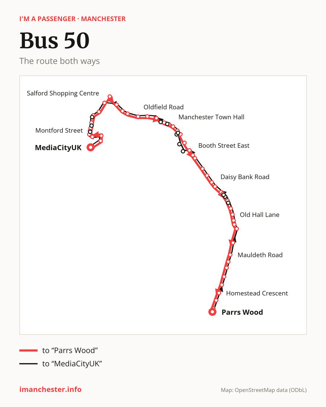
Towards “Parrs Wood”: 48 stops. After “MediaCityUK”, the bus calls at “Harbour City Metrolink Stop”, “Ohio Avenue”, “Michigan Avenue”, “Dakota Avenue”, “Montford Street”, “Eccles New Road”, “Langworthy Road”, “Wall Street”, “Salford Shopping Centre”, “Pendleton Church”. Then “Frederick Road”, “Salford Crescent Rail Station”, “University of Salford”, “Oldfield Road”, “Salford Cathedral”, “Salford Central Rail Station”, “Deansgate”, “St James Square”, “Manchester Town Hall”, “St Peter’s Square”. Then “Hart Street”, “Charles Street”, “Grosvenor Street”, “Booth Street East”, “Brunswick Street”, “Grafton Street”, “Swinton Grove”, “Hathersage Road”, “Daisy Bank Road”, “Denison Road”. Then “Upper Kent Road”, “Birchfields Avenue”, “Telfer Road”, “Old Hall Lane”, “Lytham Road”, “Fallowfield Shopping Centre”, “Moseley Road”, “Grangethorpe Drive”, “Mauldeth Road”, “Briarfield Road”. Before “Parrs Wood”: “Green End Road”, “Barcicroft Road”, “Fog Lane”, “Homestead Crescent”, “School Lane”, “East Didsbury Metrolink Stop”.
On the way back the bus takes a different route, from “Parrs Wood” to “MediaCityUK” (46 stops). Only in this direction does it call at “Birch Hall Lane”, “Dickenson Road”, “Manchester Metropolitan University”, “Chester Street”, “Dickinson Street”, “Ridgefield”, “Manchester Crown Court”, “Liverpool Street”, “Carolina Way” and “Kansas Avenue”. Only in the direction of “Parrs Wood” does it call at, among others, “Dakota Avenue”, “Montford Street”, “Langworthy Road”, “Pendleton Church”, “Deansgate” and “St James Square”. For the way back, board nearby: “Dakota Avenue” → “Kansas Avenue” (100 m), “Montford Street” → “Kansas Avenue” (50 m), “Langworthy Road” → “Liverpool Street” (100 m) and “Pendleton Church” → “Salford Shopping Centre” (350 m). Towards “Parrs Wood”, board nearby: “Birch Hall Lane” → “Birchfields Avenue” (100 m), “Dickenson Road” → “Upper Kent Road” (150 m), “Manchester Metropolitan University” → “Grosvenor Street” (250 m) and “Chester Street” → “Charles Street” (200 m).
Left column runs down, right column runs up. Filled stops are served both ways, dashed ones only one way: 12 towards “Parrs Wood” and 10 the other way. Tap a stop to see its name.
Other routes along the way
On part of the route, between “MediaCityUK” and “Michigan Avenue” it shares the road with route 29.
Connections by stop, in route order:
- Stops from “MediaCityUK” to “Ohio Avenue”: buses 53 and 79
- “Montford Street” (only towards “Parrs Wood”): bus 33
- “Eccles New Road”: buses 33 and 52
- “Langworthy Road” (only towards “Parrs Wood”): buses 52 and 79
- “Wall Street”: buses 52 and 79
- “Salford Shopping Centre”: buses 52, 53, 70, 79 and 95
- “Pendleton Church” (only towards “Parrs Wood”): buses 52, 79 and 95
- “Frederick Road”: bus 53
- “Salford Crescent Rail Station”: bus 53
- “St James Square” (only towards “Parrs Wood”): bus 114
- “Manchester Town Hall” (only towards “Parrs Wood”): buses 18, 33, 41, 42, 42A, 42B, 43, 85, 85A, 86, 87, 103, 111, 114, 142, 143, 191, 197 and 256
- “St Peter’s Square”: buses 18, 33, 41, 42, 42A, 42B, 43, 85, 85A, 86, 87, 103, 111, 114, 142, 143, 191, 197 and 256
- “Hart Street” (only towards “Parrs Wood”): buses 18, 33, 41, 42, 42A, 42B, 43, 85, 85A, 86, 87, 103, 111, 114, 142, 143, 147, 191, 197 and 256
- “Charles Street” (only towards “Parrs Wood”): buses 18, 41, 42, 42A, 42B, 43, 85, 85A, 86, 87, 103, 111, 142, 143, 147, 191 and 197
- “Grosvenor Street” (only towards “Parrs Wood”): buses 18, 41, 42, 42A, 42B, 43, 85, 85A, 86, 87, 111, 142, 143, 147, 191 and 197
- “Booth Street East”: buses 18, 41, 42, 42A, 42B, 43, 53, 85, 85A, 86, 87, 111, 142, 143, 147, 191 and 197
- Stops from “Brunswick Street” to “Swinton Grove”: buses 18, 41, 42, 42A, 42B, 43, 53, 87, 111, 142, 143, 147, 191 and 197
- “Hathersage Road”: buses 41, 42, 43, 142, 143 and 147
- “Daisy Bank Road”: buses 41, 42, 43, 142, 143 and 147
- “Denison Road”: buses 41, 42, 43, 53, 142, 143 and 147
- “Upper Kent Road” (only towards “Parrs Wood”): buses 41, 42, 43, 53, 142, 143 and 147
- “Birchfields Avenue” (only towards “Parrs Wood”): buses 41, 42, 43, 53, 142, 143 and 147
- “Telfer Road”: bus 41
- “Old Hall Lane”: bus 41
- “Lytham Road”: buses 41, 150 and 171
- “Fallowfield Shopping Centre”: buses 41, 150 and 171
- “Moseley Road”: buses 41, 150, 171 and 197
- “Mauldeth Road”: bus 25
- “Briarfield Road”: bus 25
- “Barcicroft Road”: bus 172
- Stops from “Fog Lane” to “School Lane”: buses 171 and 172
- “East Didsbury Metrolink Stop”: buses 23, 42, 42A, 42B, 142, 171 and 371
- “Parrs Wood”: buses 23, 42, 42A, 42B, 142, 171 and 371
- “Birch Hall Lane” (only towards “MediaCityUK”): buses 41, 42, 43, 53, 142, 143 and 147
- “Dickenson Road” (only towards “MediaCityUK”): buses 41, 42, 43, 53, 142, 143 and 147
- “Manchester Metropolitan University” (only towards “MediaCityUK”): buses 18, 41, 42, 42A, 42B, 43, 53, 85, 85A, 86, 87, 103, 111, 142, 143, 147, 191 and 197
- “Chester Street” (only towards “MediaCityUK”): buses 18, 41, 42, 42A, 42B, 43, 85, 85A, 86, 87, 103, 111, 142, 143, 147, 191 and 197
- “Dickinson Street” (only towards “MediaCityUK”): buses 18, 33, 41, 42, 42A, 42B, 43, 85, 85A, 86, 87, 103, 111, 114, 142, 143, 191, 197 and 256
- “Ridgefield” (only towards “MediaCityUK”): bus 114
- “Liverpool Street” (only towards “MediaCityUK”): buses 33, 52 and 79
- “Carolina Way” (only towards “MediaCityUK”): bus 33
- “Kansas Avenue” (only towards “MediaCityUK”): bus 33
Pages for these routes: bus 18, bus 23, bus 25, bus 29, bus 33, bus 41, bus 42, bus 42A, bus 42B, bus 43, bus 52, bus 53, bus 70, bus 79, bus 85, bus 85A, bus 86, bus 87, bus 95, bus 103, bus 111, bus 114, bus 142, bus 143, bus 147, bus 150, bus 171, bus 172, bus 191, bus 197, bus 256, bus 371.
Passes and concessions
Which passes are available and who travels free is explained on a separate page: how to pay for public transport in Manchester.
Questions about bus 50
Does bus 50 go to “Salford Shopping Centre”?
Yes, in both directions.
Where can I change from bus 50 to another bus route?
Most routes stop at “Manchester Town Hall” (only towards “Parrs Wood”; 18, 33, 41, 42, 42A, 42B, 43, 85, 85A, 86, 87, 103, 111, 114, 142, 143, 191, 197 and 256) and “Hart Street” (only towards “Parrs Wood”; 18, 33, 41, 42, 42A, 42B, 43, 85, 85A, 86, 87, 103, 111, 114, 142, 143, 147, 191, 197 and 256). All other stops with connections are listed above.
Checked on 23 September 2026. Source of the route and stops: Transport for Greater Manchester (TfGM).